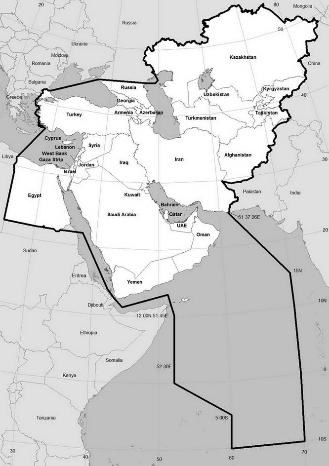
OSME Region Map1 ORL 10.2 January 2025
NB1 Some small islands, particularly in the southern Red Sea near Bab-el-Mandab, may require the sketched line of the OSME Region boundary to differ from that shown.
NB2 Presence of some species in the deep-ocean area derived from data collected by BirdLife Seabird Tracking Database hosted by BirdLife Datazone.
1 Map projection and production by Ian Fisher RSPB.
The map above does not represent precise political boundaries nor does it support any opinion where these are in dispute. It outlines the OSME Region, an ornithological concept which includes the Middle East, the Caucasus and Central Asian republics. The Region contains 35 countries or territories, namely: Egypt, Cyprus, Turkey (including European Turkey), Syria, Lebanon, Israel, Gaza, Jordan, Saudi Arabia, Yemen (including the Socotra archipelago), Oman, United Arab Emirates, Qatar, Bahrain, Kuwait, Iraq, Iran, Georgia, Armenia, Azerbaijan, the republics (Karachay-Cherkassia, Kabardino-Balkaria, North Ossetia and Chechenia) along the north slope of the Caucasus and a small part of the southernmost Russian federation (cutting through the regions of Krasnodar, Stavropoľ and Daghestan), Kazakhstan, Turkmenistan, Uzbekistan, Kyrgyzstan, Tajikistan2 and Afghanistan.
For seabird records, and records of land birds at sea, the OSME Region includes the following areas of sea or ocean:
- In the eastern Mediterranean, to the east of a line from the Egypt-Libya coastal border north-northeastwards to where the southern end of the Turkey-Greece international limits adjoin.
- The area of sea within the Turkish side of the Turkey-Greece international limits north and east to their northern end in the Bosporus.
- In the Black Sea, south of a line drawn from the European Turkey-Romania coastline border east-northeast to the southern Russian coastline in Krasnodar at 45°N, then running east along this latitude to the Caspian Sea.
- In the Caspian Sea, from the Russian Caspian coast at 45°N on that latitude to meet and follow northwards the internationally-agreed natural resources exploitation line (the mid-Caspian ‘centreline’) until that line reaches the southern Russia-Kazakhstan coastline border (east of the Volga delta).
- In the Indian Ocean, the deep-ocean area enclosed by the following: from a point on the Iran-Pakistan coastline border at 61°37΄03˝E via a great circle line to 15°N, 70°E; then south along longitude 70°E to 10°S, which latitude is followed west to 10°S, 60°E; then north to 5°S, 60°E, from which via a great circle line northwest to 0°, 52°30΄E; then north to 10°N, 52°30΄E; then from 10°N, 52°30΄E via a line projected through 12°N, 51°45΄E (the midpoint between Abd al Kuri island, the westernmost part of the Socotra archipelago, and Cape Gardafui, Somalia) to where it meets the centreline of the Gulf of Aden at 13°N, 51°E. The OSME deep-ocean area includes the entire Gulf between Iran and the Arabian peninsula, an area comprising the Arabian Sea where it meets the Indian Ocean, but excludes internationally-agreed Somalian territorial waters. Our associated organisations, African Bird Club (ABC) and Oriental Bird Club (OBC) do not yet have a published policy for recording deep-ocean bird records, keeping generally within the principle of the UN-recognised 200 nautical miles (370.4km/230.2mi) limit of national exclusive economic zones (The UN recognises 12 nautical miles (22.2km/13.8mi) territorial sea limits). OSME proposed this straightforward division of open-ocean waters of the Indian Ocean in order to simplify the allotment records of birds recorded therein. ABC and OBC have much larger deep-ocean areas to consider, and so they agreed that OSME should record bird records in the mapped area above.
- In the Gulf of Aden, the line runs westwards from 13°N, 51°E E along the Gulf of Aden ‘centreline’ to the Bab-el Mandab straits. The waters north of this line are within the OSME Region.
- In the Red Sea, the line parallels the approximate centreline but includes the international maritime routes of the Red Sea (up to the territorial limits of the African states) north from the Bab-el-Mandab straits to meet a line projecting east from the straight-line latitudinal component of the Sudan-Egypt border3, whose historical legal basis we follow. East and north of the centreline, Red Sea waters lie entirely within the OSME Region.
2 Spellings of Central Asian countries in particular vary, mostly because the sounds have been transliterated into English from different original scripts several times in history. For example, we adopt ‘Tajikistan’ because it is nowadays mostly spelt that way in correspondence from that country, but recognise that ‘Tadzhkistan’ is a common earlier alternative derived from Russian usage. This variability of spelling applies to several other countries, but our choices do not imply other spellings are inferior.
3 The OSME Region includes the Halaib triangle, legally part of Egypt but administered by Sudan on the basis of the integrity of ethnic groups therein.